Research Themes
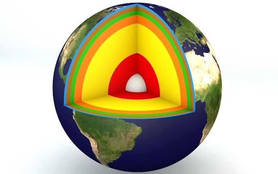
I employ and extend the tools of seismology to probe the Earth's deep interior. This involves working on planetary-scale geophysical problems using new techniques that reconcile and fit concurrently a wide variety of seismological observations. My doctoral work resulted in the next-generation three-dimensional images of the Earth’s interior, similar to a CT-scan for the human body. Recent progress includes evaluating the extent of radial anisotropy with implications for large-scale mantle flow, detecting seismological signatures of chemical heterogeneity from scaling relationships between the elastic parameters and density, as well as radial models that represent accurately the Earth’s average properties. I works with several collaborators to infer the modeled properties in terms of the dynamics and evolution of the Earth's interior. These novel methodologies also lead to a better understanding of devastating earthquakes.
Featured Research Themes
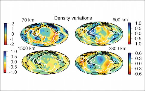
Do superplumes overly denser-than-average material?
Can we detect these anomalies?
How fast do waves travel anywhere on Earth?
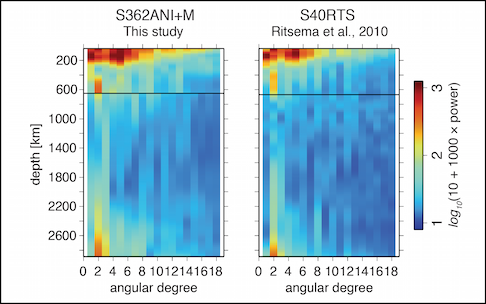
Where can radial anisotropy be robustly detected?
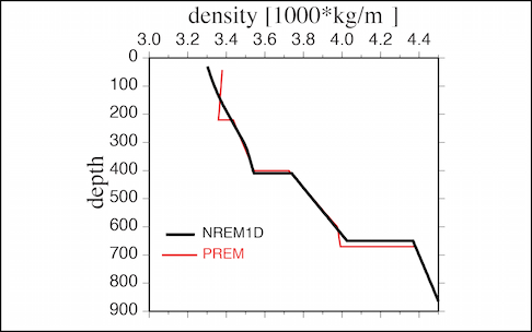
Historical discrepancies in 1-D Reference Earth Models?
.... and several other interesting questions.
Study of the Earth’s interior is an inter-disciplinary endeavor and a multitude of constraints from various fields are required to derive complementary information on Earth structure. Geochemists analyze rocks to provide constraints on the current and early composition of the mantle while mineral physicists estimate the physical properties of the rocks at high pressures and temperatures; geodynamicists model long-term deformation processes associated with the evolution of the mantle while geodesists monitor the motions on the Earth’s surface at shorter time-scales. Till date, seismology holds the distinction of providing the most uniform constraints on structure as the various types of seismic waves recorded on a global network of stations illuminate different regions of the Earth.
How do we probe the Earth's interior?
During every major earthquake, seismic waves emanate from the hypocenter and the Earth rings like a bell for several days. The ensuing free oscillations and the associated propagating body and surface waves travel to inaccessible regions of the Earth’s deep interior. These waves eventually travel back to the surface and are recorded at broad-band seismic stations around the world. Seismic-imaging methods allow us to draw quantitative inferences on Earth structure from the analysis of recorded seismograms. These methods, also known as seismic tomography, offer tantalizing images of the Earths interior and are a crucial source of information about its physical and chemical state. Studies of radial and lateral variations in seismic-wave speed have illuminated several first-order features of the Earth such as abrupt discontinuities in seismic velocities due to phase transitions in constituent minerals of the mantle, seismically fast ‘slabs’ beneath subduction zones and low-velocity ‘superplumes’ or upwellings from the base of the mantle. The seismically-derived snapshots describe the current state of the planet and allow us to infer relationships between deep, inaccessible regions and shallow features nearer to the Earth’s surface.
How is this done? What makes it unique?
The primary objective of seismic tomography is to determine the elastic, anelastic, and density structure of the Earth from observations recorded at seismic stations. The problem can be described as a system of equations, or an inverse problem, to find models of seismic sources and Earth structure that reproduce most accurately the measured data. In global seismology, three classical concepts are typically used in the interpretation of recorded seismograms. The broadband body-wave arrivals (T 1–10 s) in the first few tens of minutes of a seismogram can be analyzed using ray-theoretical methods akin to geometrical optics. The large-amplitude, dispersed surface waves (T 25–250 s) arriving in the first few minutes to hours of a seismogram are analyzed using characteristics that describe a wave packet such as group and phase velocity. The third concept is that of free oscillations of the whole Earth that manifest as resonance peaks in the spectra of very long seismograms. The spectral peaks at the longest periods (T ≥ 250 s) are fingerprints of various types of standing waves in the whole Earth caused by a major earthquake. Recently, we pioneered full spectrum seismic tomography that employs all aforementioned data types along with complete seismic waveforms, while accounting for various theoretical complexities like anisotropy and attenuation.